-40%
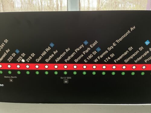
NYCTA Subway 2 Line Strip Map - Thick plastic - 10.5" x 75" - Can be backlit.
$ 83.95
- Description
- Size Guide
Description
This is the IRT #2 Strip Map as used on R142 and R142A subway cars until 2016 when they were replaced by new maps that also show the #5 line. The strip is heavy gauge plastic and can be backlit as I've shown in my photo. Note that this was used on the train and therefore has a few minor scrapes and bruises, none of which are noticeable from the usual viewing distance. The sign will be rolled for shipping but will return to its original form within a day or two. You may pick up the sign in person if you'd prefer.Stations depicted on strip map includes:
BRONX:
Wakefield - 241 St, Nereid Ave, 233 St, 225 St, 219 St, Gun Hill Rd, Burke Av, Allerton Av, Pelham Pkwy, Bronx Park East, E 180 St, W Farms Sq - E Tremont Av, 174 St, Freeman St, Simpson Av, Intervale Av, Prospect Av, Jackson Av, 3 Av-149 St, 149 St - Grand Concourse
MANHATTAN:
135 St, 125 St, 116 St, Central Park N (110 St), 96 St, 72 St, Times Square - 42 St, 34 St - Penn Station, 14 St, Chambers St, Park Place, Fulton St, Wall St
BROOKLYN:
Clark St, Borough Hall, Hoyt St, Nevins St, Atlantic Av - Barclays Center, Bergen St, Grand Army Plaza, Eastern Pkwy - Bklyn Museum, Franklin Av, President St, Sterling St, Winthrop St, Church Av, Beverly Rd, Newkirk Av, Flatbush Av - Bklyn College


